Geographic Information Systems (GIS) mappers and surveyors rely on a unique blend of technology, fieldcraft, and practical problem-solving to do their work effectively. While much of the public associates GIS with computers and digital mapping, the job often takes professionals far beyond the office and deep into remote terrain where self-sufficiency matters just as much as technical expertise. From rugged handheld equipment to simple outdoor essentials, GIS mappers and surveyors depend on a wide range of tools to gather accurate data and stay prepared for unpredictable environments.
Core Mapping Gear
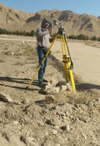 At the core of the profession are the mapping tools themselves—GPS units, total stations, drones, and rugged tablets designed to withstand harsh conditions. High-accuracy GPS receivers, sometimes capable of sub-centimeter precision, are indispensable when creating detailed land surveys or mapping environmental features. Rugged tablets and mobile data collectors allow surveyors to record data in real time, even in rain, dust, or extreme temperatures. For areas with challenging terrain or limited accessibility, drones have become one of the most transformative tools. They provide aerial imagery, 3D modeling, and rapid site assessments while reducing the need for extensive ground travel. Laser rangefinders, compasses, and old-fashioned notebooks still play an important role as well, especially when the technology encounters limitations or when redundancy is essential.
Protective Measures
 Because this work often takes place in forests, deserts, mountains, wetlands, or other undeveloped regions, surveyors must carry tools that go beyond mapping technology. Field boots, durable clothing, sun protection, power banks, portable solar chargers, and first-aid kits are standard gear. Many locations lack reliable cell service or nearby supply points, meaning that surveyors must be able to stay in the field for extended periods. This requires careful planning not only for equipment but also for food, hydration, and temperature management.
Food & Drink Preparation

One often overlooked but highly practical field tool are good cheap coolers. While high-end models are popular among outdoor enthusiasts, GIS mappers and surveyors working on a budget frequently rely on cheap but reliable coolers to store food and drinks during long days in remote locations. These inexpensive coolers can still maintain cold temperatures for many hours, especially when paired with ice packs or frozen water bottles. For field technicians hiking into remote sites or spending an entire day under the sun, having cold water and safely stored meals is more than a convenience—it is essential for safety and performance. Affordable coolers are lightweight, easy to pack into a vehicle, and durable enough to handle rough transport, making them a sensible option for field teams who need practicality over premium branding.