Geographic Information Systems (GIS) mappers and surveyors rely on a unique blend of technology, fieldcraft, and practical problem-solving to do their work effectively. While much of the public associates GIS with computers and digital mapping, the job often takes professionals far beyond the office and deep into remote terrain where self-sufficiency matters just as much as technical expertise. From rugged handheld equipment to simple outdoor essentials, GIS mappers and surveyors depend on a wide range of tools to gather accurate data and stay prepared for unpredictable environments.
Core Mapping Gear
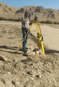 At the core of the profession are the mapping tools themselves—GPS units, total stations, drones, and rugged tablets designed to withstand harsh conditions. High-accuracy GPS receivers, sometimes capable of sub-centimeter precision, are indispensable when creating detailed land surveys or mapping environmental features. Rugged tablets and mobile data collectors allow surveyors to record data in real time, even in rain, dust, or extreme temperatures. For areas with challenging terrain or limited accessibility, drones have become one of the most transformative tools. They provide aerial imagery, 3D modeling, and rapid site assessments while reducing the need for extensive ground travel. Laser rangefinders, compasses, and old-fashioned notebooks still play an important role as well, especially when the technology encounters limitations or when redundancy is essential.
Protective Measures
 Because this work often takes place in forests, deserts, mountains, wetlands, or other undeveloped regions, surveyors must carry tools that go beyond mapping technology. Field boots, durable clothing, sun protection, power banks, portable solar chargers, and first-aid kits are standard gear. Many locations lack reliable cell service or nearby supply points, meaning that surveyors must be able to stay in the field for extended periods. This requires careful planning not only for equipment but also for food, hydration, and temperature management.
Food & Drink Preparation

One often overlooked but highly practical field tool are good cheap coolers. While high-end models are popular among outdoor enthusiasts, GIS mappers and surveyors working on a budget frequently rely on cheap but reliable coolers to store food and drinks during long days in remote locations. These inexpensive coolers can still maintain cold temperatures for many hours, especially when paired with ice packs or frozen water bottles. For field technicians hiking into remote sites or spending an entire day under the sun, having cold water and safely stored meals is more than a convenience—it is essential for safety and performance. Affordable coolers are lightweight, easy to pack into a vehicle, and durable enough to handle rough transport, making them a sensible option for field teams who need practicality over premium branding.
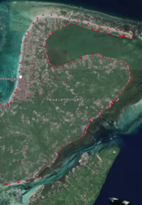
 When dredging occurs, the physical boundaries and depths of a water body are modified, often creating inconsistencies between pre-existing digital maps and the new on-the-ground reality. Since GIS relies heavily on static datasets and established topographical benchmarks, the rapidly shifting sediment and changing water levels can complicate efforts to maintain accurate spatial models. Even small-scale dredging or erosion can shift a shoreline by several feet, leading to discrepancies in land ownership boundaries, zoning regulations, or environmental protection zones. For developers and environmental planners, these inaccuracies can have costly consequences, including regulatory non-compliance, construction delays, or unintended ecological impacts. Furthermore, aquatic systems are influenced by a wide range of variables—such as rainfall, evaporation, sediment deposition, and biological growth—that continuously reshape their physical features. Capturing this variability in GIS requires frequent updates through field surveys, sonar mapping, and remote sensing, all of which demand significant time, financial resources, and technical expertise.
 From a regulatory and environmental standpoint, GIS mapping inaccuracies in aquatic development can pose serious risks. Misrepresentation of wetlands, flood zones, or aquatic habitats can result in violations of environmental laws or unintentional damage to sensitive ecosystems. For instance, dredging operations based on outdated GIS data might encroach on protected zones or disrupt fish spawning areas. To address these challenges, developers and environmental scientists are increasingly turning to adaptive GIS models that incorporate real-time monitoring data, such as sensor-based water level readings or automated drone surveys. These technologies allow for more dynamic mapping, enabling continuous updates that reflect the true conditions of a site. However, implementing such systems requires not only advanced software and hardware but also skilled professionals capable of interpreting and managing complex datasets.
 There is something to be said for country living. Things are simpler, quieter, and more relaxing if you can ditch the city and spend your time in the country. Those who live in rural areas are able to experience these relaxation areas every day of their lives. They can farm, they can have pets without leashes, and more. The downside to it is the fact that they also need to discover efficient rural power source solutions. Otherwise, things can get messy pretty quickly.
 Often, people go to the country to escape their reality. They go camping in off the grid locations. They rave about the fact that they are embracing the simple life for a short time. When its over, they say that they cannot wait to go back. They like the freedom, the peaceful quiet, the crickets chirping. They see this side of it and nothing more. In many ways, this is how it is to live in the most rural areas. However, there is another side to this tranquility.
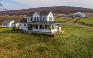 The word, “downside” is a bit harsh, but it is kind of true. In Florida, or other coastal areas, where farms are located, a hurricane can wipe out power for weeks because rural areas are last on the list for repairs. During the summer months when storms roll in daily, power can potentially go out for a few hours. Then you must also consider that rural landowners could own acres of land. How do they work the fields in the “away from the home” areas or have a powered gate? It all ends up being a little tricky since most off-grid locations do still need power consistently.
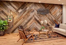 In today’s world, we have all learned the importance of using reclaimed wood. You take wood from a pallet to make other things or use wood from a dresser to create something new. You repurpose everything that you can, which ensures that it will remain useful for years to come. To learn more, read on to learn about 5 reclaimed wood uses that may surprise you.
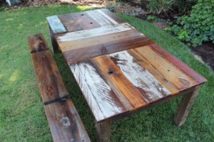 Some people love the look of wood ceilings. Either full wood slats running across the ceiling or simple wooden beams. These ceilings can make any room in your home look more rustic and beautiful. However, if you would rather not have the wood on your ceiling, the floor is always an option.
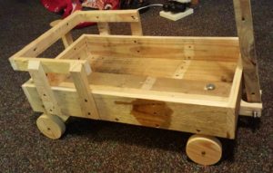 When working with reclaimed wood, not all pieces may be usable. You may have smaller pieces of wood leftover from previous projects. The beauty of this is that you can use those smaller pieces to create art. This is how mantles, shelves, and wooden shadow boxes come in. Using scraps of wood, you can create shelves that have large or small spaces. You can create window boxes for plants during the spring. The options and potential uses are endless.
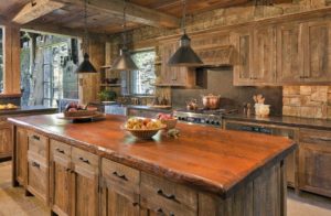 There are a lot of beautiful things created with wood. Wood is loved for the creation of everything from end tables to bedroom suits. We aren’t talking about the fake wood, with wallpaper spread over it, but the beautiful natural type. The stuff that has been planed down to create a flat surface. These woods are also useful in our home and in more ways than you may realize. For instance, did you know that creating bowls from natural resources, like wood, is increasingly popular with many?
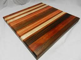 Think of a cutting board or a countertop in your kitchen. These items can be made from wood and set a very warmth to any kitchen area. The most popular types of wood for countertops are going to be walnut, teak, oak, maple, and more. Each one is beautiful, natural, and outstanding to work with.
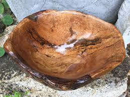 Have you ever gone to a restaurant and noticed that they served salad in a wooden bowl? Often, they can still be plastic, but they look awesome. In other cases, they may be made using maple, cherry, or black walnut. Creating bowls from wood isn’t always easy. You have the option to simply carve out a bowl or use the burls of a tree.
 Most people do not think about the fact that we have to know so much about our world and a lot of it comes through mapping it out. There are people devoted to mapping our oceans, our lands, and even what may be within the Earth’s core. Each part of mapping the Earth is important. We gain massive amounts of information from each new area mapped out.
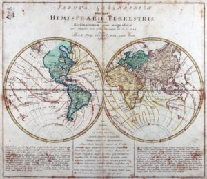 Land mapping is a little easier to see and understand. We map land so that we can see how large it is, where borders and boundaries are, how to travel from here to there, and more. Mapping makes it easy for us to see where mountains are located as well as other features of our Earth.
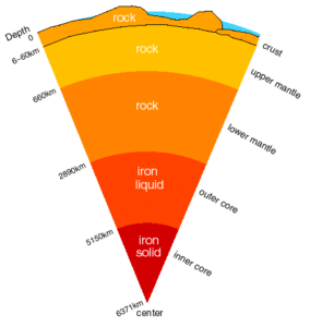 We know that Earth is made up of four layers. In the core, we have a solid iron ball. It measures about 1,500 miles in diameter. It is extremely hot and estimates are that it is approximately 9,000 and 13,000 degrees Fahrenheit. It is surrounded by a liquid iron shell that is around 1,400 miles thick. It is what keeps us on our magnetic center.